|
Fact Sheet: _MCAGCC
Twentynine Palms, California, USA
|
Quick Scroll To:
DESCRIPTION
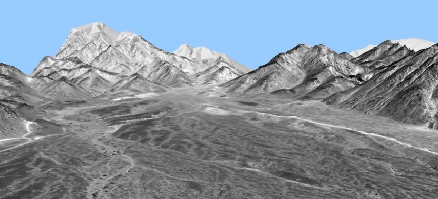
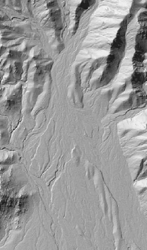
This transmittal is a high-resolution data set that
represents Range 400 (sited in a box canyon) at the US Marine Corps Air
Ground Combat Center (MCAGCC) in the Mojave Desert at Twentynine Palms,
California.
.
 _
_
_
_ 
.
The primary data source is a 1-meter digital elevation
model (DEM) and associated orthophoto generated from large-scale aerial
photography by Raye Norvelle at the US Army Topographic Engineering Center
(TEC). Based on extensive ground control, the vertical accuracy of this
DEM is estimated to be an extraordinary 0.15 meter root-mean-square-error
(RMSE).
The DEM extends over an area of 2.1 km East-West
by 3.2 km North-South.
Sited in a box canyon, Range 400 is used to conduct
company-level live-fire training in a deliberate assault against prepared
defensive positions.
This data set was put to use at Twentynine Palms
under the DARPA Leathernet Project. Since 1995, it remains a benchmark
for high-resolution terrain representation of a desert area.
Both gridded and polygonal data sets are provided
in the download.
DATA CONTENT
.
Gridded Data
AUTM Database Extents:
- Lower left corner: (592750.00, 3795670.00)
- Upper right corner: (594913.00, 3798945.00)
- Minimum elevation value: 0.00 (meters)
- Maximum elevation value: 0.00 (meters)
DRM Classes Used:
- AUTM Location 3D
- Absolute Time Interval
- Absolute Time Point
- Access Citation
- Classification Data
- Data Quality
- Description
- Environment Root
- Environmental Domain Summary
- Keywords
|
- Point Of Contact
- Process
- Property Grid
- Property Grid Hook Point
- Regular Axis
- Spatial Domain
- Table Property Description
- Transmittal Root
- Transmittal Summary
- Union Of Geometry Hierarchy
|
EDCS Classification Codes Present:
- ECC_LAND
- ECC_OBJECT
- ECC_SPOT_ELEVATION
.
Polygonal Data
Polygons: 119673
Area: 5.5 km2
AUTM Database Extents:
- Lower left corner: (593000.00, 3796000.00)
- Upper right corner: (594900.00, 3798900.00)
- Minimum elevation value: 679.79999 (meters)
- Maximum elevation value: 1148.00 (meters)
DRM Classes Used:
- AUTM Location 3D
- Absolute Time Interval
- Absolute Time Point
- Access
- Ambient Colour
- Attribute Set
- Attribute Set Index
- Attribute Set Table
- Attribute Set Table Group
- Attribute Set Table Library
- Citation
- Classification Data
- Classification Related Geometry
- Data Quality
- Description
- Diffuse Colour
- Emissive Colour
- Environment Root
- Environmental Domain Summary
- Image
- Image Library
- Image Mapping Function
|
- Inline Colour
- Keywords
- Point Of Contact
- Polygon
- Presentation Domain
- Primitive Colour
- Process
- RGB Colour
- Reference Vector
- Rendering Properties
- Spatial Domain
- Spatial Index Data
- Spatial Index Related Geometry
- Specular Colour
- Texture Coordinate
- Translucency
- Transmittal Root
- Transmittal Summary
- Union Of Geometry Hierarchy
- Union Of Primitive Geometry
- Vertex
- .
|
EDCS Classification Codes Present:
COMPATIBILITY INFORMATION
This data set is compliant with SEDRIS 3.1.x.
POINT OF CONTACT
Send email to [email protected] / [email protected] for questions or assistance in using this data
set.
As a minimum, please provide the following in your
email:
- data set name
- SEDRIS compatibility version
- hardware architecture
- OS name and version
- detailed problem description
DOWNLOAD
- FILE
|
- SIZE
|
- 29palms_3.1.zip
|
- 27.0M
|
.
|
Last updated:
_January 28, 2004
|